Avertissement de tempête :
L’école pourrait être fermée si les conditions météorologiques et des routes ne permettent pas de circuler en sécurité. Veuillez noter que l’école pourrait aussi être fermée en cas de panne d’électricité. * voir avertissement Environnement Canada ci-dessous
Dans l’éventualité d’une fermeture de l’école, un message sera écrit sur le site web de l’école et vous recevrez également un courriel de l’école avant 7h30 le jour même.
Si vous êtes dans l’impossibilité d’accéder à l’internet, le réseau français de Radio-Canada (97,7 FM) ainsi que la chaîne locale de Nanaimo – The Wave (102,3 FM) and the Wolf (106,9 FM), annonceront l’interruption du service de transport ou la fermeture d’école le plus tôt possible. Nous vous prions également de ne pas entrer en communication directement avec les chauffeurs ni la compagnie d’autobus pour obtenir ces renseignements.
Storm Alert :
The school may be closed completely when weather and road conditions are such that driving presents a safety risk. Please note that the school could also be closed during power outages. * see Environment Canada Alert below
In the event of a school closure, a message will be posted to the school website and parents will also receive an e-mail from the school before 7:30 am.
If you can’t access internet, the French radio station Radio Canada (97.7 FM) and the local station The Wave (102.3 FM) and the Wolf (106.9 FM), will announce the bus service interruption and/or school closure. Please do not call the bus drivers or the bus company directly regarding closures.
Weather Event Impacts:
Potential for tree damage, power outages, flooding and landslides.
Weather Event Estimated Start Time and Duration:
Thursday through Sunday.
Description:
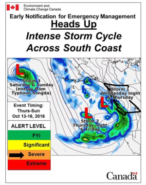
A series of intense storms will deliver prolonged heavy rain and strong winds to the South Coast beginning Wednesday evening:
- The first storm will reach the South Coast late Wednesday evening spreading the first round of heavy rain and strong south-east winds. Winds will likely exceed warning criteria (>80km/h) for the west side of Vancouver Island and perhaps Greater Victoria.
- A second round of strong winds and heavy rain is expected to begin late Thursday/early Friday with the arrival of storm #2.
- The third and potentially most vigorous storm is expected on Saturday when the remnants Typhoon Songda approach the South Coast. This third storm will be slow moving and produce heavy rain into Sunday.
- Currently, forecast models are suggesting the possibility for Saturday’s storm to intensify into a major storm. If the forecast holds, widespread damage from extreme winds is likely.
- Daily rainfall amounts will be in the 50-80mm range. Total rainfall amounts from the three storms could be in excess of 200mm along coastal sections and even higher over the North Shore mountains.
Confidence Level:
MODERATE Forecast models are in good agreement regarding overall intensity of the storm cycle. Given that Saturday’s storm is still 4 days out, there is still plenty of time for the forecast to change. As always, forecast certainty will increase with time as the storms approach. Please monitor the latest forecasts and warnings as they will change.
Recommendations:
Prepare for potential power outages. Ensure culverts and storm drains are free of debris. Monitor forecasts and alerts for updates.
For updates and alerts:
Environment Canada Forecasts: www.weather.gc.ca/forecast/canada/index_e.html?id=BC
Environment Canada Alerts: www.weather.gc.ca/warnings/index_e.html?prov=bc
BC River Forecast Centre Flood Warnings & Advisories: https://bcrfc.env.gov.bc.ca/warnings/index.htm
Environment Canada Weather Blog: www.avalanche.ca/weather
*****Early Notifications are intended for the Emergency Management Community. Please restrict distribution.*****